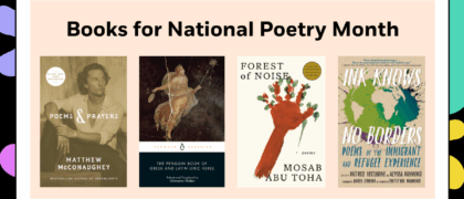
Atlas of World War II

History's Greatest Conflict Revealed Through Rare Wartime Maps and New Cartography

Look inside
This definitive, lavishly illustrated book from National Geographic features an astonishing array of vintage and newly created maps, rare photographs, covert documents, and eyewitness accounts that illuminate the world’s greatest conflict.

This magnificent atlas delves into the cartographic history of WWII: naval, land, and aerial attacks from the invasion of Poland to Pearl Harbor and the Battle of the Bulge. Rare maps include a detailed Germany & Approaches map used by Allied forces in the final stages of the war, full large-scale wartime maps of the world used by President Roosevelt, and crucial Pacific theater maps used by B-17 pilots.

Satellite data renders terrain as never before seen, highlighting countries and continents in stunning detail to include the towns, cities, provinces and transportation roads for a pinpoint-accurate depiction of army movements and alliances. Gripping wartime stories from these hallowed fields of battle, along with photographs, sketches, confidential documents, and artifacts color the rest of this timeless and informative book.
NEIL KAGAN, editor, heads Kagan & Associates, Inc., a firm specializing in designing and producing innovative illustrated books. Recently, he edited Great Photographs of World War II, Smithsonian Civil War, and for National Geographic, as well as the best-selling Concise History of the World, Eyewitness to the Civil War, Atlas of the Civil War, The Untold Civil War, Eyewitness to World War II and The Secret History of World War II. Author STEPHEN G. HYSLOP has written several books on American history, including National Geographic's The Secret History of World War II, Eyewitness to World War II, Eyewitness to the Civil War, and The Old West. His articles have appeared in American History, World War II, and the History Channel Magazine. Consultant KENNETH W. RENDELL is the founder and director of the International Museum of World War II, which houses the world's most comprehensive collection of original artifacts and documents relating to the causes, events, and consequences of World War II.
“Thoughtfully curated and beautifully designed, this volume is sure to appeal to military history aficionados and anyone with an unadorned coffee table.” –Library Journal

"...perhaps the greatest history and WWII book I have read. Not only does it give great detail about how the war was fought, but it also shows what the greatest generation gave, risked and lost during the war...Never did I feel overwhelmed or bogged down with text; the visuals compelled me to devour this title quite quickly." --Jennsbookshelves

“In addition to these marvelous maps, the book presents many fascinating details on the advancement of cartography during the war, in particular how the amazing new capabilities of rapidly advancing science of aerial reconnaissance photography was merged with traditional mapmaking to produce the incredibly detailed charts used for planning some of the wars most important amphibious invasions. The attention to detail and precision required for many of these maps almost makes them now seem like ancient works of art.” –NY Journal of Books

“I thought this book was incredible, it covers all theaters of the war, provides copies of the maps the generals used (along with their notes on them), a bunch of propaganda and just interesting tidbits along the way. The book is fun to browse, find an interesting section and delve into it. Frankly I found the whole book incredibly compelling – especially if you like maps.” – Man of La Book
 
“One of my favorite parts of this book is that it spends some time talking about escape maps for downed airmen and there are maps that show possible routes that they could have taken to safety. There is a fantastic picture included that shows tiny compasses that were hidden in parts of military uniforms or among their other supplies, like inside of buttons or as part of belt buckles. This fascinates me.” –Into the Hall of Books
 
“Atlas of World War II manages to bridge both the Western and the Eastern Fronts, as well as events in the Pacific, with substantive details, something that isn’t always accomplished so successfully…allows for readers to appreciate the full scope of what was happening. Each page becomes a time capsule of that point in the war, with the slow but painful progression toward Allied victory.” –Dwell in Possibility

“…there were unique gems in this collection. Among them, a small number of old Japanese maps, some for military use in China and a world map for public consumption, were most interesting…German naval navigation charts of waters off North America were captivating as well. Last but not least, as I looked closely, some of the maps reproduced in this volume actually contained front line notes penciled in by the commanders who used them.” –World War II Database

About

This definitive, lavishly illustrated book from National Geographic features an astonishing array of vintage and newly created maps, rare photographs, covert documents, and eyewitness accounts that illuminate the world’s greatest conflict.

This magnificent atlas delves into the cartographic history of WWII: naval, land, and aerial attacks from the invasion of Poland to Pearl Harbor and the Battle of the Bulge. Rare maps include a detailed Germany & Approaches map used by Allied forces in the final stages of the war, full large-scale wartime maps of the world used by President Roosevelt, and crucial Pacific theater maps used by B-17 pilots.

Satellite data renders terrain as never before seen, highlighting countries and continents in stunning detail to include the towns, cities, provinces and transportation roads for a pinpoint-accurate depiction of army movements and alliances. Gripping wartime stories from these hallowed fields of battle, along with photographs, sketches, confidential documents, and artifacts color the rest of this timeless and informative book.

Author

NEIL KAGAN, editor, heads Kagan & Associates, Inc., a firm specializing in designing and producing innovative illustrated books. Recently, he edited Great Photographs of World War II, Smithsonian Civil War, and for National Geographic, as well as the best-selling Concise History of the World, Eyewitness to the Civil War, Atlas of the Civil War, The Untold Civil War, Eyewitness to World War II and The Secret History of World War II. Author STEPHEN G. HYSLOP has written several books on American history, including National Geographic's The Secret History of World War II, Eyewitness to World War II, Eyewitness to the Civil War, and The Old West. His articles have appeared in American History, World War II, and the History Channel Magazine. Consultant KENNETH W. RENDELL is the founder and director of the International Museum of World War II, which houses the world's most comprehensive collection of original artifacts and documents relating to the causes, events, and consequences of World War II.

Praise

“Thoughtfully curated and beautifully designed, this volume is sure to appeal to military history aficionados and anyone with an unadorned coffee table.” –Library Journal

"...perhaps the greatest history and WWII book I have read. Not only does it give great detail about how the war was fought, but it also shows what the greatest generation gave, risked and lost during the war...Never did I feel overwhelmed or bogged down with text; the visuals compelled me to devour this title quite quickly." --Jennsbookshelves

“In addition to these marvelous maps, the book presents many fascinating details on the advancement of cartography during the war, in particular how the amazing new capabilities of rapidly advancing science of aerial reconnaissance photography was merged with traditional mapmaking to produce the incredibly detailed charts used for planning some of the wars most important amphibious invasions. The attention to detail and precision required for many of these maps almost makes them now seem like ancient works of art.” –NY Journal of Books

“I thought this book was incredible, it covers all theaters of the war, provides copies of the maps the generals used (along with their notes on them), a bunch of propaganda and just interesting tidbits along the way. The book is fun to browse, find an interesting section and delve into it. Frankly I found the whole book incredibly compelling – especially if you like maps.” – Man of La Book
 
“One of my favorite parts of this book is that it spends some time talking about escape maps for downed airmen and there are maps that show possible routes that they could have taken to safety. There is a fantastic picture included that shows tiny compasses that were hidden in parts of military uniforms or among their other supplies, like inside of buttons or as part of belt buckles. This fascinates me.” –Into the Hall of Books
 
“Atlas of World War II manages to bridge both the Western and the Eastern Fronts, as well as events in the Pacific, with substantive details, something that isn’t always accomplished so successfully…allows for readers to appreciate the full scope of what was happening. Each page becomes a time capsule of that point in the war, with the slow but painful progression toward Allied victory.” –Dwell in Possibility

“…there were unique gems in this collection. Among them, a small number of old Japanese maps, some for military use in China and a world map for public consumption, were most interesting…German naval navigation charts of waters off North America were captivating as well. Last but not least, as I looked closely, some of the maps reproduced in this volume actually contained front line notes penciled in by the commanders who used them.” –World War II Database

Books for Asian American and Native Hawaiian/Pacific Islander Heritage Month

Every May we celebrate the rich history and culture of Asian Americans, Native Hawaiians, and Pacific Islanders. Browse a curated selection of fiction and nonfiction books by AANHPI creators that we think your students will love. Find our collections of titles here: Middle School High School

Read more

PRH Education High School Collections

All reading communities should contain protected time for the sake of reading. Independent reading practices emphasize the process of making meaning through reading, not an end product. The school culture (teachers, administration, etc.) should affirm this daily practice time as inherently important instructional time for all readers. (NCTE, 2019)   The Penguin Random House High

Read more

PRH Education Translanguaging Collections

Translanguaging is a communicative practice of bilinguals and multilinguals, that is, it is a practice whereby bilinguals and multilinguals use their entire linguistic repertoire to communicate and make meaning (García, 2009; García, Ibarra Johnson, & Seltzer, 2017)   It is through that lens that we have partnered with teacher educators and bilingual education experts, Drs.

Read more

PRH Education Classroom Libraries

“Books are a students’ passport to entering and actively participating in a global society with the empathy, compassion, and knowledge it takes to become the problem solvers the world needs.” –Laura Robb   Research shows that reading and literacy directly impacts students’ academic success and personal growth. To help promote the importance of daily independent

Read more